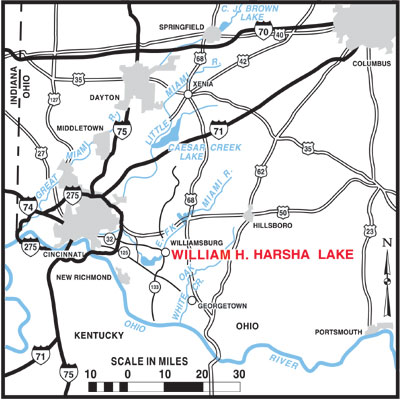
These driving directions are to the U.S. Army Corps of Engineers Visitor Center located at 2185 Slade Road, Batavia, Ohio, 45103. Note: If you use MapQuest, GPS or similar tools, the visitor center is located approximately one and a half miles further on Slade Road, just past the main dam and boat ramp. The East Fork State Park campground is located off SR 32 and the Half Acre Road exit. The East Fork State Park Office, Main Beach, and other day-use facilities are located on OH-125 and Bantam Road.
WilliamHHarshaLakeMap.pdf
From Cincinnati, Ohio: Merge onto I-71 South toward Louisville. Merge onto I-471 South via Exit Number 1J toward Newport, Ky. Merge onto I-275 East via Exit Number 1A- on the left- toward Columbus, Ohio. Take the OH-125 exit- Exit Number 65- toward Amelia/Beechmont Ave. Turn right onto OH-125/Ohio Pike. Continue to follow OH-125. Turn left onto OH-222. Turn right onto Slade Road. End at 2185 Slade Road, Batavia, Ohio. Distance is approximately 28 miles.
From Dayton, Ohio: Merge onto I-75 South via the ramp- on the left- toward Cincinnati. Merge onto I-275 East via Exit Number 16 toward I-71/Columbus. Take the OH-125/Beechmont Avenue exit-- Exit Number 65- toward Amelia. Turn left onto OH-125/Ohio Pike. Continue to follow OH-125. Turn left onto OH-222., Turn right onto Slade Road. End at 2185 Slade Road, Batavia, Ohio. Distance is approximately 69 miles.
From Columbus, Ohio: Merge onto I-71 South. Merge onto I-275 East via Exit Number 17A toward OH-32. Take the OH-125/Beechmont Avenue exit--Exit Number 65- toward Amelia. Turn left onto OH-125/Ohio Pike. Continue to follow OH-125. Turn left onto OH-222. Turn right onto Slade Road. End at 2185 Slade Road, Batavia, Ohio. Distance is approximately 116 miles.
From Indianapolis, Ind.: Merge onto I-65 South. Merge onto I-74 East via Exit Number 106. Merge onto I-75 South toward Lexington. Take the exit on the left. Take the I-71 North exit-- Exit Number 1A- toward I-471 South/Exits 1B-C-D/US-50 East/Downtown. Merge onto US-50 East. Merge onto I-471 South. Merge onto I-275 East via Exit Number 1A- on the left- toward Columbus, Ohio. Take the OH-125 exit- Exit Number 65- toward Amelia/Beechmont Avenue. Turn right onto OH-125/Ohio Pike. Continue to follow OH-125. Turn left onto OH-222. Turn right onto Slade Road. End at 2185 Slade Road, Batavia, Ohio. Distance is approximately 136 miles.
From Lexington, Ky.: Merge onto I-75 North toward Louisville/Cincinnati. Merge onto I-275 East via Exit Number 185. Take the OH-125 exit-- Exit Number 65- toward Amelia/Beechmont Avenue. Turn right onto OH-125/Ohio Pike. Continue to follow OH-125. Turn left onto OH-222. Turn right onto Slade Road. End at 2185 Slade Road, Batavia, Ohio. Distance is approximately 100 miles.