The rivers of America have been used for centuries as part of a transportation network — literally water highways — carrying goods and commodities vital to the Nation’s economic well being.
The Ohio River Basin comprises a large geographic area of the United States east of the Mississippi River - 204,000 square miles and containing nearly 25 million people. It reaches northeast into New York, west to Illinois, and south through the drainage area of the Tennessee River in Georgia, Alabama, and Mississippi. Through the heart of this vast area, the 981 mile-long Ohio River carries the largest volume of water of any of the Mississippi River tributaries. The Ohio is formed by the juncture of the Allegheny and Monongahela rivers at Pittsburgh, Pennsylvania, and empties into the Mississippi at Cairo, Illinois.
The U.S. Congress recognized the importance of the inland waterways when, in 1824, it authorized the U.S. Army Corps of Engineers to undertake its first Civil Works mission — the removal of snags and other obstructions to navigation on the Ohio and Mississippi rivers. In addition, the Ohio’s flow was improved by the construction of wing dams or dikes to concentrate flow into the main channel. In spite of these efforts, safe navigation was still sporadic and seasonal. In dry months the water was so shallow in places that was fordable only by people and horse-drawn wagons. River men and shippers came to rely on two “rises” or “tides.” The fall rise occurred in late October or November, and the spring rise between February and April. Navigation improvements were needed that would provide safe, yearround, dependable means of moving vessels on the river.
After the Civil War, the movement of coal downriver from Pittsburgh increased greatly and the size of coal tows grew in length as powerful steam towboats pushed more and more wooden barges. To accommodate the burgeoning coal trade, the Corps studied means of providing a dependable navigation depth on the Ohio. Following an international investigation of navigation projects, engineer officers concluded that the Ohio could best be improved by constructing a series of locks and dams to create slack water pools.
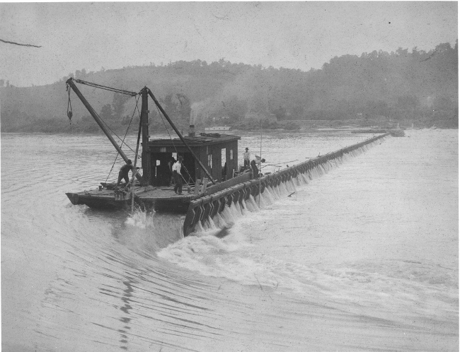
The first complete lock and dam project built by the Corps of Engineers on the Ohio was at Davis Island, a few miles below Pittsburgh. This lock and dam opened to traffic in 1885. The project proved its worth, and in 1910 Congress passed the Rivers and Harbors Act. This Act authorized construction of a riverlength system of locks and dams which would provide a nine-foot navigation depth. When completed in 1929, the “canalization” project consisted of 51 movable dams with wooden wickets and a lock chamber measuring 600 feet by 110 feet. At low water stage, the dams were raised to pool water thus requiring lockage. At high water the wickets were lowered, allowing vessels to avoid the locks through “open river” navigation. The canalization project proved successful for many years, moving millions of tons of goods and contributing nobly to the American war effort in World War II.
In the 1940s, the transition from steam to diesel-powered towboats enabled tows longer than the 600 foot locks to move on the river, requiring “double locking” when the string of barges had to be locked through in two maneuvers. This was a hazardous and time consuming operation causing traffic delays resulting in increased costs to the towing industry.
In the 1950s, the Corps undertook the Ohio River Navigation Modernization Program to replace the obsolete system of wicket dams and small locks. Each of the new 18 high-lift concrete and steel dams replaced at least two of the old structures. Each dam consisted of two locks, one 600 feet by 110 feet, the other 1200 feet by 110 feet. Use of the 1200-foot chamber allows the towboat and up to 15 barges to transit the lock in one maneuver. At Smithland Locks and Dam there were twin 1200-foot chambers built creating the only such navigation project in the world at the time. The locks and dams on the Ohio serve a navigation purpose only; they do not provide flood control.
The Corps of Engineers’ role in providing a safe navigation infrastructure on the Ohio River is a mission without end. Locks and Dams 52 and 53 on the lower river were the last of the old wicket dams and were replaced by the Olmsted Locks and Dam project, which became operational in 2018. To accommodate projected traffic increases at McAlpine Locks and Dam at Louisville, a second 1200-foot lock was completed in 2009. In addition, studies are underway to determine the best method to enhance lock operations at other Ohio River projects.
The Louisville District Corps of Engineers operates seven navigation structures on the Ohio, from Markland Locks and Dam downriver to the mouth. The projects operate 24 hours a day, 365 days a year, serving both the towing industry and recreational boaters.